1. Starting
When people say “Cairo map,” they usually mean a graphic (printed or digital) of the Egyptian city of Cairo that shows its streets, landmarks, rivers, and neighborhoods. “Cairo Africa map,” on the other hand, usually indicates a map that illustrates where Cairo is in relation to Africa, or at least where Egypt is in Africa (or a nearby area). These tiny differences in wording illustrate that the two terms have different meanings and purposes. One is for cities and the other is for regions or continents.
In this essay, I'll discuss about these phrases: what they mean, how they're used, where they came from, and why I think they are important.
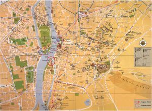
2. What does the “Cairo map” mean?
Most of the time, when you ask for a “Cairo map,” you mean a map that simply displays Cairo. For instance,
- The main roads, the Nile River that runs through them, the neighborhoods, and the important places.
- Maps for tourists that show mosques, pyramids, museums, and the city's center.
- Maps that illustrate metro lines, ring roads, and neighborhoods for city planners or those who work in transportation.
Cairo is “the capital of Egypt and one of the largest cities in Africa,” according to the Encyclopedia Britannica. It has been in its current spot on the banks of the Nile River for about 1,000 years. (Encyclopedia Britannica)
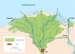
So, making a map of Cairo isn't just about new highways and buildings; it's also about the city's long history of growth, its ancient sites, and its geography (the river, delta, and desert nearby).

What do you need a map of Cairo for?
- Getting around the city and discovering the key sights, including the pyramids on the Giza Plateau, is easy for a visitor.
- For a student: to see how Cairo is on the Nile, which is on the edge of the desert.
- For an urban geographer: to learn about how the city has grown, how traffic moves, and how the metro system operates (the Cairo metro is the oldest in Africa). (Wikipedia)
You can see the following on a map:
- A map of the streets in central Cairo.
- A map of Greater Cairo that illustrates the governorates that are nearby.
- A map with a topic, like one that displays how many people live in different parts of Cairo.
3. What does “Cairo Africa map” mean?
People don't use the phrase “Cairo to Africa map” as much, but it denotes a map that depicts where Cairo is in relation to the rest of Africa (and sometimes the Middle East). It shows that you want to know more than just the city. You want to know where Cairo is in relation to Africa and maybe even the nearby areas of Asia, the Mediterranean, and so on.
For instance:
- A map of Egypt in northeastern Africa that displays its borders and the countries that share them. These countries are Libya, Sudan, Israel, and the Mediterranean Sea. (geographicguide.com)
- A map of Africa that lets you zoom in on or mark Cairo's location on the continent.
- Cairo, Egypt is an important place on maps of Africa that are meant for learning or reference.
Why is this useful?
- Use the Sinai Peninsula to show how Egypt connects Africa and Asia, and use Cairo to show how close it is to the Nile Delta.
- For global awareness: recognizing that Cairo is not just a city but also part of Africa, on the northeastern extremity of the continent.
- For comparative or thematic mapping, Africa's cities, capitals, and their locations, with Cairo being one of the most important cities in Africa. (WorldAtlas)
“Cairo Africa map” is more about where Cairo is in Africa than “Cairo map” is about the city itself.
4. The value of geography and location
The two types of maps demonstrate major differences in how we view Cairo, not just in words. Here are a few basic facts about geography that demonstrate why these discrepancies in maps are crucial:
- Cairo lies in the northeastern portion of Egypt, largely on the east bank of the Nile River. It is downstream from the Aswan High Dam area. (Encyclopedia Britannica)
- Egypt is a country that is on two continents. It has land in Africa and Asia's Sinai Peninsula. This is what makes Cairo and Egypt stand out on the map. (geographicguide.com)
- The lower Nile breaks into two rivers and spills into the Mediterranean Sea approximately north of Cairo. A lot of people think that Cairo is the “gateway” to the Delta. (Encyclopedia Britannica)
- Cairo is one of the key southern points of the Mediterranean coast in Africa. You can get to the Sinai/Asia from here, which is virtually as far east in Africa as you can get.
5. You can observe historical and cultural layers on the maps
Maps of Cairo and maps of Cairo in Africa illustrate more than just the area's physical features; they also show its history and culture:
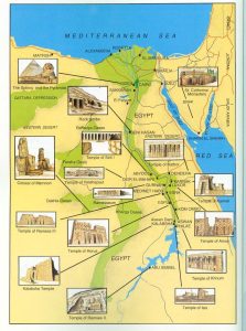
- The ruins of Memphis and the Giza Pyramid complex are two examples of ancient Egyptian settlements that are close to modern-day Cairo. (Encyclopedia Britannica)
- The Fatimid Caliphate created the city as we know it now in the 10th century. (Encyclopedia Britannica)
- Cairo's skyline is made up of old monuments, medieval neighborhoods (Islamic Cairo), structures from the colonial era, and modern skyscrapers. A map can help you understand how these layers work together.
- The continental map shows Egypt's role in African history (old civilizations along the Nile), trade in the Mediterranean, and Arab and Islamic culture.
Maps are more than simply ways to get around; they tell tales about places and times. A “Cairo map” might show you the winding lanes of old Islamic Cairo, but a “Cairo Africa map” helps you think about how Cairo became such a busy place.
6. How to use the maps and why to choose one over the other
Here are some examples from real life.
- If you want to navigate around the city, you can acquire a map of Cairo that depicts the metro lines, tourist spots, neighborhoods, and walking paths.
- A map of Cairo, Africa depicts Egypt's location, its borders with Libya and Sudan, its shoreline on the Mediterranean and Red Seas, and the general area around Cairo.
- If you're studying African megacities in a city, you may compare “Cairo map” (urban sprawl) with “map of African cities,” which shows Cairo and other cities.
- To make a travel poster more interesting and useful, you may put a detailed city map (like a Cairo map) inside a continent map (like a Cairo Africa map).
You can choose a map based on what you want to do: view the specifics of the area or obtain a wider perspective.
7. A picture that highlights the differences between the maps
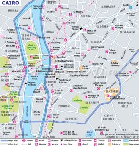
Cairo Map
- The street grid, the main boulevards, and the Nile River that flows and separates.
- Neighborhood names: Zamalek, Old Cairo, and Garden City.
- The Citadel, the Al-Azhar Mosque, and the Egyptian Museum are all important places to see.
- The subway, highways, and ring roads are all methods to get about.
- Maybe the size should be small (city scale) to show how far people had to walk.
Cairo on a map of Africa
- The shape of the continent of Africa or the northeastern region of Africa.
- Some of the countries that are mentioned are Egypt, Libya, Sudan, and others.
- Egypt's capital city is Cairo.
- To the north is the Mediterranean Sea, and to the east is the Red Sea.
- There can be a grid of latitude and longitude lines that illustrates where the place is in northern Africa.
To put it another way, one map is larger and the other is smaller.
8. How can these maps help us understand the world and our own region?
The difference is essential from a European point of view (as I write this with a European tone) because:
- Many Europeans may have heard of Cairo, but they may not know where it is in Africa or how its geography connects to Europe, the Middle East, or Africa. The “Cairo to Africa map” helps make sense of that.
- Cairo is one of the biggest cities in Africa, and the area around it has tens of millions of inhabitants. If you know how big it is and where it is, you'll understand urban Africa better. (WorldAtlas)
- Egypt is where African Nile civilization, Mediterranean culture, and Arab and Islamic history all come together. This is a fantastic site to learn about how things have changed over time. The maps show off the intersection.
- You can get a better idea of the city and the continent by looking at both the city map and the Africa map.
9. Some not-so-obvious notes about language and how to use it
- Most of the time, when someone writes “Cairo map,” they mean a map of the city of Cairo. If the word contains “Africa” in it, like “Cairo Africa map,” it denotes a bigger map.
- Someone might type “Cairo map” into a search engine when planning a trip to Cairo. They might look for “Cairo Africa map” to show where Cairo is when they are giving a presentation about Africa.
- A poster that says “Cairo Africa Map” can display Africa with Egypt shaded and Cairo in bright colors. A “Cairo Map” poster can include realistic streets and places in central Cairo.
10. Last thoughts
In short, the word “Cairo map” is about Cairo itself: its districts, prominent places, and the Nile that runs through it. By situating Cairo in Africa (and maybe surrounding locations), the phrase “Cairo Africa map” gives it a bigger geographical and continental perspective. One is good for depth, and the other is good for context.
If you're going to Cairo, getting ready to teach geography, or just curious about how cities and continents interact, knowing the differences will help you choose the right map for your requirements.
(4 Package discover Cairo )
or chat with us